
Picture of the north end of Brook Street taken from the
bridge
over the brook in Smith Street. This picture is from the
early
1900s and shows the telegraph poles going to the post and telegraph
office in Brook Street. |

Brook Street in the 1930s or early 1940s. A cottage on the
left
of the street was bombed and destroyed during the second world war. |

The north end of Brook Street with Randall's Cottage, in the early
1960s. The electricity cables have bee joined by new concrete
streetlights. |

A view along the last part of Brook Street towards Boxworth Road, with
the butcher's shop in the distance. |

This picture shows the north end of Brook Street in the early 1900s
with the footbridge over the brook in the foreground and Knibbs
butchers shop on Boxworth Road in the background. |

Picture of the north end of Brook Street looking towards Boxworth Road.
The butchers shop is visible on the opposite side of Boxworth
Road. |

This picture shows Brook Street looking south from a position opposite
the end of Cotterell's Lane. It may have been taken after
1915
since the Three Horseshoes pub sign seems to have been taken down and
this closed in 1915. |

View of Brook Street from the footbridge by the end of Cotterell's Lane
in the early 1900s. The telegraph connection to the post
office
is visible. |

A view across Brook Street towards Long Gable from Cotterell's Lane in
the early 1960s. The power cables and new concrete
streetlights
are visible. |

View from the end of Cotterell's Lane looking across Brook Street.
The cottage on the left is now a single house and the cottage
to
the right was destroyed by bombing.
The dilapidated roof of a barn that stood in the Causeway can be seen
in the background. |

A woman and child standing outside what is now No 2 Brook Street (The
Old Bakehouse) in January 1922. The edge of the bakehouse can
be
seen on the left and the roof appears to be thatch while the house roof
is slate. |

Picture of Brook Street looking south during the winter, showing how
muddy the roads became.
This picture dates from approximately 1909. |
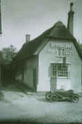
The Plough in the 1920s or 1930s looking in better repair.
Huntingdon Fine Ales are long gone. |

Brook Street in 1900s showing the Three Horseshoes pub and beyond it a
grocer's shop. The post and telegraph office is at the end of
the
row of buildings. |

This view shows the a very similar view to the previous picture as it
was in the early 1900s. The Three Horseshoes pub sign is
visible
in the foreground. The telegraph poles connect the post
office
at the end of the street. |

Long Gable before Brook Street was bombed, destroying the cottage next
to Long Gable and the end of Long Gable itself. |

This view shows the Plough and Long Gable during a flood sometime
before the second world war when Brook Street was bombed. |

Long Gable after the war with Brok Street flooded. The
neighbouring cottage has gone along with half of Long Gable.
Electricity has arrived in Elsworth as well. |

Picture of Brook Street looking south in the early 1900s. The
bakery opposite has a large wall at the front that has gone. |

Another flood in Brook Street. The telegraph pole and street
lamp
are in the flood but it has not reached the Three Horseshoes. |

A picture looking down Brook Street from outside Throssell's shop
looking north. This must have been taken before 1915 when the
Three Horseshoes ceased to be a pub. The telegraph wire to
the
post office further down is present so it must be after 1901. |

This picture shows the view from the Causeway just above the Dolphin
across Brook Street. The sign of the Three Horseshoes
opposite is
visible. |

This picture shows Throssell's shop on Brook Street. At this
point in time the roof of the main building was thatched but is now
tiled. |


These pictures are similar to a previous picture but show a wider view
of
Throssell's shop on Brook Street. At this
point in time the roof of the main building was thatched but is now
tiled. The pictures must be earlier than 1915 as the sign of
the
Three Horseshoes pub can be seen in the distance and this pub closed in
1915. |

A postcard of Elsworth from the 1920s or 1930s showing
Throssells
shop on the left and on the corner of the Causeway the coalyard at no
1. There was a large door at the rear of the shed opening
onto
Brook street. Shell petrol is advertised on the side of the
carpenters shop. |

The old schoolhouse in Brook Street, again in the early 20th century.
The cookery school on the Causeway can be seen in the
background. |

Picture of the schoolhouse in Brook Street in the early 20th century. |

This shows some of the school pupils outside the schoolroom around
1900. A postcard of this dated 1903 exists indicating it must
be
prior to this date. |

The old schoolhouse in Brook Street. The building looks a
little
run down so this may be not long before it closed. The
schoolroom
on the Causeway is visible in the background, as is the building that
became the post office in the 1970s. |


Picture showing the bottom of the Causeway with the Dolphin Inn and the
Plough. This picture dates from about 1915. The version on
the left is a slightly cropped version of the one on the right. |

A view looking north along Brook Street. This is a commercial
postcard, probably from the 1940s. There is still no
electricity
and the Three Horseshoes does not seem to be a pub any more.
The
Plough is still open. |
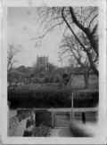
View across Brook Street from the front door of the old post office
showing the church in the background. The street lamp that
used
to stand by the sluice has gone. |
|

Picture of the wheelwright shop in the 1900s together with the old oil
lamp that stood by the sluice and the telegraph pole for the telegraph
to the old post office. The original steep thatched roof of
the
tithe barn can be seen in the background. |

This picture shows the old post office, possibly in the very early
1900s before the telegraph was installed. |

The old post and telegraph office seen from the far side of the brook.
The oil lamp that stood by the sluice is visible on the far
right
and in the background is the tithe barn with the original thatched roof. |

The post and telegraph office in Brook Street in the early 1900s.
The sharpening wheel and bits of wood belonging to the wheelwright's
shop next door can be seen next to the driveway . |

The post and telegraph office is on the left with the sign and post box
by the door. In the background at the top of the yard is the
blacksmith shop which is still present. |

A view of Brook Street from opposite Holworthy Cottage looking north,
probably in the late 1920s or early 1930s. Electricity has
not
yet arrived and the old oil lamp is still standing opposite the post
office. The street water supply from the mains is also visible. |

Brook Street in the 1920s showing the sluice gate at the northern end
of the culvert and watering place for animals. The
wheelwright's
workshop is on the left next to the last telegraph pole. |

The view along the brook from the sluice showing the cottages on the
western side. It is summer and the brook is overgrown, the
date
is probably late 1940s or early 1950s as power or telephone wires can
be seen along the bank. The old oil lamp post and water
spigot
are also still there. |

This view shows the brook largely dried up. A pony and trap
on
the road shows the typical transport of the time. |

This picture shows the old butcher's shop that stood at the southern
end of Brook Street, and a now vanished cottage that seems badly
damaged. The remains of the butcher's shop still exist. |

View southwards along the brook from the sluice showing cottages and
barns a
in the early 1900s. |

This photograph shows (right to left) Disbrowe Cottages, Low Farm, the
butcher's shop and Daniel's Barn with the brook running between them.
The road seems to be just a dirt track so the picture was
probably taken in the early 20th century. |

A photo of Disbrowe Cottages, probably in the early 1900s.
This
seems to be a similar view to the Raphael Tuck postcard which is
earlier
than 1902. A now vanished cottage adjoins what it now Jasmine
Cottage. |
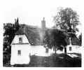
Disbrowe Cottages in the early 20th century. On the left of
the picture the end of another cottage is visible. This
cottage no longer exists but may have been replaced by a prefabricated
bungalow that used to stand in the next plot. |
|

This view shows taken in the early 1900s shows a small cottage that
originally stood across from Low Farm. It has long since
vanished
but the original plot is still visible. |

This picture shows Brook Street flooded, the depth indicated by the
horse and cart. The view seems to be looking west towards the
old
butcher's shop. The cottage seen in the centre is long gone,
and a
barn was built on the roadside there. |

This picture shows Low Farm taken from the paddock behind the building.
This paddock was built on in the 1970s. |

This postcard shows a group of cottages in Brook Street around 1901.
Most of the buildings pictured are still standing today. |

Brook Street looking south from the sluice showing Disbrowe cottages
and Daniel's barn.
This picture was on a card postmarked 1913. |


Low Farm, possibly in the 1920 or 1930s. There is no sign of any
electricity wires suggesting it was taken before 1938.
|

Low Farm in the early 1900s, showing that in those days Brook Street
was an unpaved track. |

This is a drawing of Low Farm made in 1930 by Lawrence
Iggulden,
vicar of Elsworth from 1927 to 1946. |

Low Farm, possibly in the 1930s or 1940s. The cottage in the
background has since vanished. |

Randall's Cottage in the 1990s taken from the junction with Smith
Street and Boxworth Road. |

Randall's Cottage in the 1990s taken from Smith Street.
|

Randall's Cottage with building work going on in the 1990s. |

The northern end of Brook Street in the 1990s showing Randall's Cottage
and Knibbs butchers shop (now a house). |

Brook Street flood in 1983 viewed from Boxworth Road. Until
recently floods have been a regular feature of life in brook Street. |

Northern end of Brook Street showing Randall's Cottage and Knibbs
butchers shop in the winter of 1958-1959. |

The view was taken from the end of Cotterell's Lane looking across
Brook Street in the 1980s. |

View across Brook Street from Cotterell's Lane in 1983 flood. |

View of a cottage in Brook Street opposite the end of Cotterell's Lane
around 1980. |

The Cottage (No 11) during the 1990s. |

View southwards along Brook Street during 1983 flood showing The Bakery
and Horseshoe Cottage. |

Looking south from Cotterell's Lane towards Long Gable and the Plough
during the 1983 flood. |
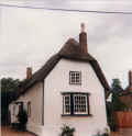
The Plough in Brook Street in the 1980s. |

The Plough in Brook Street in the 1990s. |

This view shows the eastern side of Brook Street around 1980 with the
Plough and Long Gable visible. |
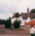
The centre of Brook Street with the Plough and Long Gable in the 1980s. |

View of the house with former bakery to the left around 1990. |

The Old Bakehouse (built c1843)
showing the bakehouse at the end in the 1990s. |

Long Gable in Brook Street in the 1990s. The house is largely
unchanged today. |
|

In the mid 1960s relief culverts were laid from the sluice to the
remaining waterway at the end of Cotterell's Lane to reduce the
flooding in Brook Street. |

The new culverts viewed from outside Horseshoe cottage. |

This view shows the west side of Brook Street opposite the Causeway
around 1980. Horseshoe Cottage (formerly the Three Horseshoes
pub) in the foreground. |

Houses along the west side opposite the Causeway in the 1990s.
At
this time the wheelwright shop at the end was being converted to
residential. |
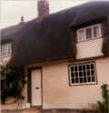
Horseshoe Cottage in the 1980s. |

View of Horseshoe Cottage around 1990 (formerly the Three Horseshoes
pub). |

No 10 in the 1990s, formerly a shop. There have been changes
to
the building since with chimney pots added to the large
square
chimney stack. The street is unusually clear of parked cars. |

View of No 10 Brook Street around 1990, formerly a grocer and
haberdashery shop until the 1960s. |

View across Brook Street of the old Throssell shop and wheelwright
workshop beyond in the 1990s. Both are now residential. |

Looking south from the middle of Brook Street in the 1980s. |
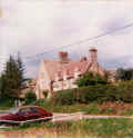
The Old Schoolhouse in the 1980s after renovation. |

The old schoolhouse after extensive restoration work. |

The bottom of the Causeway and the Dolphin in the 1990s. The
large barn used by the coalyard has gone along with the school fence
but the rest is largely unchanged. |

Brook Street looking north showing the sluice and the wheelwright
wprkshop and the village shop in the winter of 1958-1959. |
|

Brook Street flooded at the south end around 1990. |

Looking south from Smith Street during a major flood. |

Looking north at flooding from the bottom of the Causeway in 1993. |
|
|

Building work during the conversion of the wheelwright shop and garage
to residential use in the 1990s. |
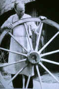
J W Throssell the wheelwright with a cartwheel made for exhibition in
the 1950s. The old wheelwright shop is in the background. |

The old post office, also known as "Two Ways", in the 1990s. |

View along Brook Street from the southern end around 1980.
New
bungalows next to Low Farm are visible on the right. The old
butcher's shop building is also largely intact. |

Brook Street looking north along the brook in the winter of 1958-1959. |

View of the brook and sluice in 1986. The wooden rails have
since
been replace with concrete posts and pipes. |

A winter scene in Brook Street in the 1980s. |

The view along the brook from the sluice in the 1980s. The
old
barn on the left has now very largely collapsed. |

Looking south towards Disbrowe Cottages in the 1980s. The old
barn can be seen on the left; it has since collapsed. |

Looking north from Disbrowe Cottages in the 1980s. The old
barn
is still standing and the tangle of power lines can be seen. |

Holworthy Cottage in Brook Street in the 1990s. This was
originally two cottages that were renovated and converted into one
house in the 1960s. |

A cottage in Brook Street that has been modified over the years.
A recent feature of cottages in the area has been the
addition of
tall chimney pots because of the thatch. |

Jasmine Cottage in the 1990s. The cottage has changed
substantially since with the tree on the left being removed and an
extension built to the left of the cottage. The porch has
also
been demolished. |

Building new houses on the meadow beside the schoolhouse in 1965. |

New bungalows at the bottom of the meadow completed 1966. |

One of two pairs of semi-detached bungalows built in the 1960s.
The left hand bungalow is the only one of the four that has
not
been extended since then. |
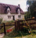
Disbrowe Cottages in Brook Street during the 1980s.. |

Disbrowe Cottages in the 1990s. They are largely unchanged
today |

One of two modernist bungalows built in the late 1960s/early 1970s at
the southern end of Brook Street. |

This small bungalow stood in a field at the south end of the street,
reached only by a footpath. It was demolished in the 1990s
and
replaced with a large house and a vehicle bridge was built over the
brook for access. |

Low Farm at the end of Brook Street in snow during the winter of
1961-1962. |

The front of Low Farm during the 1980s. |

The well at Low Farm in the 1980s. Many houses along Brook
Street
had their own well. |
|
|

The view looking west from the eastern side near Church Lane winter
2010. Jasmine Cottage is in the centre of the picture. |

The view northwest across Brook Street from near Church Lane in the
winter of 2010. Holworthy Cottage and Two Ways (the old Post
Office) are in the background. |

The view northwest across Brook Street from near Church Lane in the
winter of 2010. Two Ways (the old Post Office)
and houses to the north are in the background. |
|
|

This picture of the pupils of Elsworth school was taken in 1926 or
1927. |

This picture of Group 1 pupils of Elsworth school was taken in 1921.
Disbrowe Cottages can be seen in the background. |

Class 1 of 1923 at the old schoolhouse in Brook Street. |
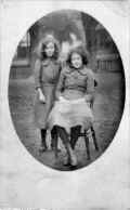
Daisy and Nell Richardson in the old schoolyard, probably in the early
1900s. Horseshoe cottage can be seen in the background but
the
pub sign is obscured by the tree. |

School pupils at the old schoolhouse in Brook Street, probably during
the 1920s. This picture was a formal photograph of a class by
"Scholastic Souvenirs Co., Bispham, Blackpool". |
